Journey Map NZ

Journey Map NZ

Journey map - oz

Journey map - oz

Journey Map

Journey Map

Monday, 1 February 2010

Into South Australia

Sunset on Perlubie Beach, North of Streaky Bay, South Australia
Cave on the coast approaching Port Lincoln
National Park at Port Lincoln. Much of this land has been left untouched since the early explorers mapped the area. I went for a swim in shark infested waters. Apparently there is a tuna fishing operation round the corner and it is a feeding ground for Great Whites. At least I know for next time.
Single Mangrove surviving in the salt water, North of Port Lincoln
Wheat belt of South Australia - gentle rolling hills. Time to swap my Western Australian Emu bitter for South Australia Coopers Pale Ale. Tasty!
Camping has been largely free or minimal fee for as long as I can remember. A few places have honesty boxes for a few dollars but much of the land in the National parks and road sides is only a few dollars a night or completely without charge!

Crossing the Nullabor

This sign greets you as you turn on to the Eyre highway.

"Where are you headed? " I was asked in the petrol station.
"Sydney" I said.
"Down the road, turn right and keep going for 4000 kilometres" was the reply. I laughed slightly nervously as I considered all the moving parts that could fail on my 1986 Toyota and the distance I was about to take it.


Much of the way there is vegetation - trees, shrubs, grass etc. However the road does pass through the South part of the Nullabor plain. This was one of the last trees before the plain starts and it is easy to see why not many survive after this point. This area experiences extremes of temperature, lack of water and strong winds (guess which way they blow!)
Nullabor roadhouse - on the outskirts of the plain. Mobil petrol station (I thought Mobil was no more)
A welcome sight on day 2. The Great Australian Bight.
An emergency air strip on the road. There were several of these during the journey for the Royal Flying Doctors Service.
90 Mile Straight. Australias longest straight road. Apparently there is an attractive nymph who frequents the desert near the road! So I was told - I looked but must have missed this time. I was tempted to turn round and look again but thought better of it.
The Nullabor. Tree-less but plenty of shrubs as far as the eye can see.
All things considered it wasn't lonely or boring or even that long a drive compared to what I was expecting. Sure it is a long way and if the car fails a big (and expensive) problem but it was just over 20 hours actual drive time between the towns of Norseman and Ceduna.

I passed one man on a push bike - that is a real challenge.

Friday, 22 January 2010

Two peoples Bay


I forgot to put these pictures in of my favourite camping spot so far - Two Peoples Bay , East of Albany. I camped metres from the beach.

Gold mining country - Kalgoorlie - Boulder

This is the Super Pit where the gold is no longer found in nuggets but needs to be extracted from the dust and rock. Each dump truck carries several hundred tonnes of rock but only around 1 gram of gold is extracted from each tonne.

This road up the side of the super pit is as wide as a 6 lane motorway. The dumper truck at the top of the picture is 166 tonnes and can take a payload of 225 tonnes. It dwarfs the regular lorry in the bottom of the picture.
This was once a very busy station.
Some old miners houses. I'll take my tent thanks.
Nice looking hotel. I would like to have stayed here but ended up free camping out of town in a picnic area. Parked my tent on an ants nest and spent the night squashing the suckers. Saw a great sunset and sunrise though!

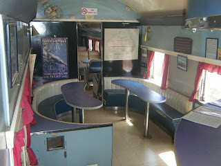
Below is a 60's buffet car which was in regular use on the Perth - Kalgoorlie line.

In the late 19th Century Paddy Hannan and his friend Flannigan found gold here.As you would imagine this prompted a gold rush and Kalgoorlie was once one of the largest towns in Australia.
Today it is home to the "Super Pit" - many of the old shaft mines were bought up by one developer called Bond and he began a huge open cut mining operation.

They have been digging the same hole for over sixty years so as you can imagine it's not one you'd want to fall down. I'll let the pictures to the talking.

Apart from that there are a few interesting buildings, a brothel scene that is ignored by authorities as it is deemed a historic part of the town and an old steam railway. Unfortunately the steam engine was not running at the time of my arrival! I considered waiting but they said it will be at least 3 years before the engine and track have been restored.

Time to move on... to the Nullabor plain which will probably take me a few days so see you on the other side! It is around 2700kms from Perth to Adelaide. I am 550kms East of Perth. Its a long way so I've got some good tunes for the car.

Albany - ex whaling town

Frenchman Bay where you can see the remnants of a Norwegian whaling operation (red bricks in the foreground)
At whaleworld - the giant skeleton of a small blue whale. This one is 30m long but they grow to around 36m.
One of the smaller tow boats used to take the dead floating whales inshore after the larger whaling ship had arrived. They floated because compressed air was pumped into them after harpooning.
Once on dry land the carcasses were carved up and boiled down into oil. This particular instrument is the head saw. It was messy and very smelly on this deck.
Jaw bones of the blue whale

This is Albany where until the 1970's many whales were hunted and killed for their precious and useful oil. It has some nice old buildings, picturesque coastline and whaleworld - the old whaling station has now been turned into a museum / whale information centre.

I was equally impressed by the Sicilian butcher in the local supermarket who made all sorts of fine Italian dishes and packed them in to reheatable containers. The meat section here was very good - certainly the best variety of cuts I have seen outside a butcher.

Tuesday, 19 January 2010

Walpole Wilderness

This is big tree country and it is such a contrast to the bush of the North West. Huge Jarrah and Tingle trees tower over the forest. This is a small river next to the camping ground at Snottygobble Loop. I just had to go there!


Giant Tingle tree which has been hollowed out by fire during the 50's - not an unusual occurrence in the forest. It stayed alive because the living part is just beneath the bark. It is possible to walk inside it is so large. There was a similar tree down the road which you could drive a car into. So many people posed with their cars, even campers, that the delicate root system was damaged and the unthinkable happened - it fell down! This trees roots are protected on the outer side of the trunk by a board-walk, just visible in the picture.

Contrasting burnt and living material


The ultimate tree house. The upper platform is 60m high and is named after a Welshman - Dave Evans who is a notable tree lover in the area. Usually these trees are used for fire spotting and the method of climbing is walking up metal stakes rammed into the wood as a ladder. This however is more for tourist purposes.


Big Brook Dam


Margaret River Wine country

I made the journey South from Perth to wine country and with the help of the book "Free Camping in the South West" bagged this beauty spot all to myself, and a few locals who dropped in for a swim. It is called Canebreak Pool and has local freshwater crayfish (marron) living within. I also spotted a large lizard who took refughe by diving into the pool.
Some adventurous bikers made this little kicker ramp - if only I had a bike!
Vineyard or winery - Windance near Margaret River


Surfers out at Yallingup Reef. Mediterranean climate means it rarely gets over 32 degrees C
There are some seriously good breaks here which get really big when the swells come in.

A shot of my tyre after too much heat I think. Certainly wasn't burn outs as my 1.6 Corolla probably wouldn't provide on that front. That said I havn't tried...yet!


Langland, Swansea

Langland, Swansea

Fiordland, NZ

Fiordland, NZ